Science
Earth from space: 3 hurricanes form a perfect line before smashing into land
Where is it? North Atlantic Ocean.
What's in the photo? Hurricanes Katia, Irma and Jose in a near-perfect line.
Which satellite took the photo? Suomi National Polar-orbiting Partnership (Suomi NPP).
When was it taken? September 8, 2017.
In this 2017 satellite photo, a trio of hurricanes — including one of the most powerful tropical storms of the last decade — formed a near-perfect line as they marched through "hurricane alley." Some of the swirling storms, which initially appear to be in the wrong order, later made landfall in the U.S. and Mexico.
The three hurricanes — Katia (left), Irma (center) and Jose (right) — were spotted by the Suomi NPP weather satellite, which is co-run by NASA and the National Oceanic and Atmospheric Administration (NOAA). While they appear to be following one another, the storms are each Traveling in a different direction: Katia made landfall in Mexico on Sept. 9; Irma struck Florida on Sept. 10; and Jose eventually dissipated off the New England coast on Sept. 22.
Most Atlantic hurricanes form in the same expanse of water between Northwest Africa and the Gulf of Mexico, dubbed hurricane alley. However, it's rare to see so many of them so close together — and forming such a regimented line, according to NASA's Earth Observatory.
Major Atlantic storms are named alphabetically based on the order they appear in each year's hurricane season. So it might seem strange that Katia is in front of both Irma and Jose in the queue to make landfall.
However, the storms did not form in the order they appear in the image. Irma formed first, on Aug. 30 near Africa's Cape Verde islands. Jose appeared next on Sept. 5 in the mid-Atlantic, not far from where it is in the photo. Katia also formed on Sept. 5, slightly after Jose, but was birthed in Mexico's Bay of Campeche, which is why it is closest to land in the photo.
Related: 12 amazing images of Earth from space

Hurricane Irma was the most destructive of the three storms. This powerful Category 5 storm triggered storm surges up to 8 feet (2.5 meters) high, unleashing as much as 20 inches (50 centimeters) of rain in certain areas and spawning at least five separate tornadoes, according to the National Weather Center. One person was killed directly by its winds, which reached a maximum speed of 130 mph (210 km/h), while up to 33 people were killed indirectly by the storm.


When is Suns - Lakers? Times, how to watch on TV, stream online | NBA preseason


Natasa returns to Bollywood after divorce from Hardik Pandya

What injury does Cowboys WR Brandin Cooks have? How long will he be out?


NFL Jets vs Vikings Same Game Parlay at +1245 odds | Pickswise
NFL best bets and Expert Week 5 Picks & Predictions | Pickswise


-
 Science23h ago
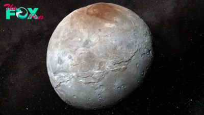
James Webb Space Telescope deciphers the origins of Pluto's icy moon Charon
-

 Science1d ago
'Many more ancient structures waiting to be discovered': Lost chunk of seafloor hidden in Earth's mantle found off Easter Island
-
 Science1d ago
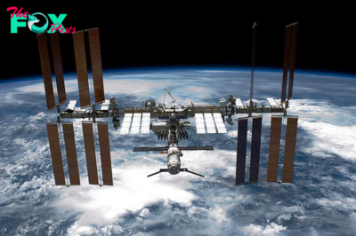
What to Know About the Leak at the International Space Station: ‘A Top Safety Risk’
-

 Science1d ago
Hranice Abyss: The deepest freshwater cave on Earth and a conduit to a 'fossil' sinkhole
-

 Science1d ago
Record spike in earthquakes at Washington's 'high threat' volcano sends researchers scrambling for answers
-
 Science1d ago
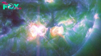
X9 solar flare launched from sun is the biggest in 7 years — and Earth is in the firing line (again)
-
 Science1d ago
Astronomers prepare for once-in-a-lifetime event: A 'new star' in the night sky
-
 Science2d ago
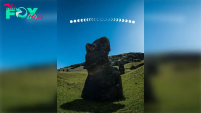
'Ring of fire' solar eclipse blazes over Easter Island in incredible new image