US News
Tornado watch in effect for parts of Texas and Louisiana, thunderstorms to develop
A tornado watch was issued for portions of the South, including parts of eastern Texas, northwestern Louisiana and much of Arkansas on Monday.
The tornado watch lasts until 9 p.m. local time, according to the National Weather Service.
Strong to severe thunderstorms will develop across the region with the possibility of damaging winds, hail and a brief tornado risk overnight, putting 22 million Americans, from Texas to Tennessee, under alert.
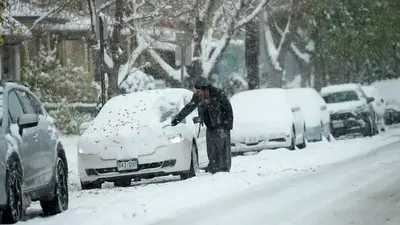
MORE: Winter storm bringing snow, ice and tornadoes, expected to wallop US this week
Thunderstorms will develop ahead of a cold front making its way through southeast Texas late Monday night into Tuesday morning, according to the NWS.

Additionally, the storms could also produce flash flooding through Monday night. Flood watches are in effect.
By Tuesday, the severe storms will shift east across Mississippi and Alabama, with flooding and damaging winds possible from New Orleans to Montgomery, Alabama.
The same storm system that brought flooding to California over the weekend has now moved into the Central U.S., bringing the winter storm to the North and the severe weather and flooding to the South.
At least 22 states, from California to Indiana, are under alert for heavy snow, dangerous ice, high winds and flooding rain.
MORE: San Francisco sees record rain as flooding shuts down highway
More than 3 feet of snow fell in the Sierra Mountains in California over the weekend. According to the UC Berkeley Central Sierra Snow Lab, up to 7.5 inches of snow fell per hour on Saturday in the Sierras.
Over a foot of snow and winds over 40 mph is possible in Nebraska, South Dakota and Minnesota on Monday and Tuesday, potentially causing driving conditions and power outages.
The ice event began on Monday afternoon and will continue throughout the day, with snow falling and covering the ice on Tuesday morning.


Why you should get a personal colour analysis | The Express Tribune

Endometriosis linked to risk of early death | The Express Tribune

When is Ravens - Chargers? How to watch on TV, stream online | NFL


New Paltz Holiday Celebration Returns with a Carnival and Parade


-

 US News6h ago
How TIME and Statista Determined the Best Companies and Colleges for Future Leaders for 2025
-

 US News6h ago
World’s Best Brands – United States
-

 US News22h ago
Florida Man Arrested and Charged With Planning to Bomb the New York Stock Exchange
-

 US News1d ago
U.S. Gathers Global Group to Tackle AI Safety Amid Growing National Security Concerns
-

 US News1d ago
Texas Offers Trump Land on U.S.-Mexico Border for Potential Mass Deportations
-

 US News1d ago
4B Is Not the Winning Strategy to Resist the Patriarchy People Think It Is
-

 US News1d ago
‘Bomb Cyclone’ Threatens Northern California and Pacific Northwest
-

 US News2d ago
Climate Action in Trump 2.0