US News
This is what it's like to fly inside a powerful hurricane
Flying into the eye of a powerful hurricane is not for the faint of heart.
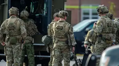
But when a tropical cyclone churns toward U.S. coastlines or begs to be studied, a brave crew of National Oceanic and Atmospheric Administration hurricane hunters make the harrowing flight through the eye wall of the storm multiple times to gather data. NOAA runs missions with this type of plane twice a day to gather this info which informs computer models and then allows emergency response agencies and residents to prepare for what's to come.
On Wednesday, ABC News chief meteorologist Ginger Zee flew into Hurricane Lee, then a Category 3 storm forecast to impact parts of the Northeast with high surf, rip currents and coastal erosion starting on Friday. Coastal New England, New Brunswick and Nova Scotia should see the direct impacts this weekend.

After taking off from Lakeland, Florida, the crew flew east-southeast for two hours toward the eye wall, plowing through 115 mph winds in a bumpy, nausea-induced flight. The plane then made several passes through the eye wall, flying in a butterfly pattern, in an effort to measure several parts of the storm.
The crew released 21 tube-like instruments called dropsondes from the plane, which use a variety of sensors to transmit data about the surrounding atmosphere back to scientists during their descent.
Dropping them from around 8,000 feet, the researchers gather critical data -- like temperature, pressure and wind speed -- which is then entered into computer models. Since they started being employed four decades ago, dropsondes have kept getting smaller, better and allowing meteorologists to predict hurricanes much earlier than in the past.
MORE: Hurricane Lee live updates: Wind, rain heading to Massachusetts, Maine
The information within the eye wall of a hurricane is important for forecasts and without it, meteorologists would only be able to forecast powerful storms about four or five days out, Jack Parrish, a former flight director for NOAA who has passed through the eye wall of a hurricane more than 700 times over the last 43 years, told ABC News.

When Parrish first started working with the National Hurricane Center in the 1980s, meteorologists could only forecast storms about 72 hours in advance, he said. Improvements into satellites and forecast models in the mid-1990s allowed for a five-day forecast.
Today, the NHC can put out a seven-day forecast with reasonable confidence, Parrish said, describing the advancement as a "100% improvement" over the span of his career.
"We also keep populating our coastlines dramatically, so those long-term forecasts are absolutely necessary," Parrish said.
MORE: Hurricane Lee becomes rare storm to rapidly intensify from Cat 1 to Cat 5 in 24 hours
Aboard the two NOAA aircraft used by the hurricane hunters, named "Kermit" and "Miss Piggy" after the beloved Muppets characters, are at least a dozen instruments -- five of them radars.
The winds are often so strong that the pilots practice "crabbing," flying sideways with the plane nose toward the wind, in order to get all of the instruments in the ideal spots, according to NOAA.

Another reason why these missions are imperative to hurricane forecasting is because warmer ocean waters are allowing storm systems to rapidly intensify.
Over the past decade, more than two dozen storms have rapidly intensified in the Atlantic basin, many just as they approach land.
MORE: This is how many billion-dollar disasters have struck the US this year
The hurricane hunters can measure data like sea surface temperature and wind shear in order to determine the likelihood of rapid intensification to occur, NOAA pilot Adam Abitbol told ABC News.
"Absent the information from this plane, we could see a dramatic difference in the tracking intensity forecast," Abitbol said.

Hurricane Lee, which saw a rapid intensification from a Category 1 to Category 5 storm in less than 24 hours, is the third-fastest intensification that we've recorded in the Atlantic basin, Abitbol said.
NOAA is also incorporating drones at sea and in the air to further the accuracy of its forecasts.
MORE: 'Above normal' activity predicted for remainder of 2023 Atlantic hurricane season, NOAA says
Sail drones, unmanned vessels that float on the ocean surface, transmit data to NOAA as a hurricane passes through.
NOAA is also testing dropping drones out of its planes during the hurricane hunting missions, which will fly around and gather even more data.

These instruments will just add to the equation -- making as close to a 3D picture of a hurricane as possible -- but they will never replace the hurricane hunter, Abitbol said.
"The only way to get that observable data in the storm is to take an aircraft and a man or a crewed aircraft in there," he said.


10 Ultra-Luxury Ski Resorts Around The World

WATCH: Vivek Oberoi gifts expensive car to his father | The Express Tribune


Democrats Need a New Immigrant Playbook

Maybe Trump Won’t Get His Way on Everything

Dallas Cowboys missing $100m of talent against the Washington Commanders

This is Alina Thyregod: Bears’ QB Caleb WIlliams’ Danish girlfriend

Pogba watches Miami Heat with Messi’s closest colleague


-

 US News1h ago
Matt Gaetz Says He Won’t Return to Congress Next Year
-

 US News22h ago
Judge Delays Trump Hush Money Sentencing to Decide What’s Next
-

 US News1d ago
Wisconsin Man Admits He Faked His Death and Left His Family for Europe
-

 US News2d ago
How TIME and Statista Determined the Best Companies and Colleges for Future Leaders for 2025
-

 US News2d ago
World’s Best Brands – United States
-

 US News3d ago
Florida Man Arrested and Charged With Planning to Bomb the New York Stock Exchange
-

 US News3d ago
U.S. Gathers Global Group to Tackle AI Safety Amid Growing National Security Concerns
-

 US News4d ago
Texas Offers Trump Land on U.S.-Mexico Border for Potential Mass Deportations