Science
Hurricane Milton: Jaw-dropping images taken from space show the storm rapidly intensifying as it approaches Florida
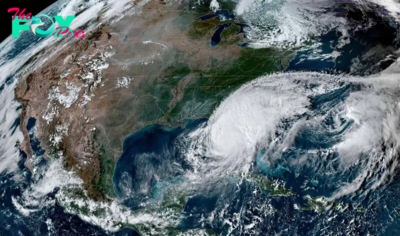
Eerie new footage from the International Space Station (ISS) captures Hurricane Milton explosively intensifying into a Category 5 storm as it moves toward Florida.
The video was taken by one of the ISS's external cameras as it flew over the hurricane at 10:28 a.m. EDT (2:28 p.m. GMT on Monday (Oct. 7). It shows the extremely dangerous storm's pinhole eye and powerful 180 mph (290 km/h) winds, according to the National Hurricane Center. Pinhole eye hurricanes are storms with tiny eyes, just a few nautical miles in diameter, which can rapidly intensify to become extremely powerful and deadly.
"This is nothing short of astronomical. I am at a loss for words to meteorologically describe [to] you the storms small eye and intensity," Noah Bergren, a meteorologist at Fox 35 Orlando, wrote on the social platform X. "This hurricane is nearing the mathematical limit of what Earth's atmosphere over this ocean water can produce."
Milton transformed from a Category 1 to a Category 5 in a matter of hours on Monday, defying hurricane models and stunning forecasters to become the fifth most intense Atlantic storm in recorded History. It has since dropped to a Category 4 storm, a strength it is expected to remain at until it makes landfall at Tampa Bay on Wednesday night (Oct. 9) or Thursday (Oct. 10) morning.
Related: We may need a new 'Category 6' hurricane level for winds over 192 mph, study suggests
This is far from the only footage of the monster storm captured from space. Images of Milton from the National Oceanic and Atmospheric Administration's (NOAA) Geostationary Operational Environmental Satellite (GOES) show the hurricane spinning just above the Yucatan Peninsula.
The black and red toward the center indicate cold temperatures, which shows that convection — where heat and moisture are transported vertically in the atmosphere — runs deep, indicating more intense thunderstorms, according to NOAA.


2024 RSM Classic: Final round 4 Sunday tee times and pairings | PGA Tour


Russell Westbrook Mocks Lakers On Instagram After Nuggets win

UNWRA Chief Philippe Lazzarini on the U.N. Agency’s Future in Gaza

The price of freedom | The Express Tribune


-

 Science4d ago
Inside Capitol Hill’s Latest UFO Hearings
-
 Science4d ago
You Won’t Want to Miss the Leonid Meteor Shower. Here’s How and When You Can See It
-

 Science5d ago
Here’s What Trump’s Win Means for NASA
-

 Science1w ago
Why Risky Wildfire Zones Have Been Increasing Around the World
-

 Science1w ago
It’s Time to Redefine What a Megafire Is in the Climate Change Era
-

 Science1w ago
4 Astronauts Return to Earth After Being Delayed by Boeing’s Capsule Trouble and Hurricane Milton
-

 Science1w ago
The Elegance and Awkwardness of NASA’s New Moon Suit, Designed by Axiom and Prada
-

 Science2w ago
SpaceX Launches Its Mega Starship Rocket. This Time, Mechanical Arms Catch It at Landing