US News
Hurricane Milton Is Now a Category 5 Storm. Here’s Its Expected Path
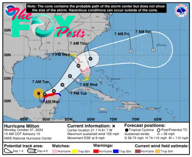
Hurricane Milton, which began as a tropical storm, has rapidly intensified into a Category 5 hurricane, according to a Monday advisory by the National Hurricane Center (NHC). The storm could make landfall in Florida as early as Wednesday evening and is currently 715 miles away from Tampa in the Gulf of Mexico.
An Air Force Reserve Hurricane Hunter aircraft found that Milton is sustaining winds measuring 160 mph that can be felt up to 30 miles from the storm’s center. Milton could prove disastrous as it Travels closer to the northern coast of the Yucatan Peninsula and arrives as Florida—and many other states across the South—is still cleaning up debris from Hurricane Helene. Mandatory evacuation orders in Florida are in place for four counties as of Monday morning.
On Saturday afternoon, Florida Governor Ron DeSantis declared a State of Emergency for 35 counties, writing that the storm will impact “communities still recovering from recent major Hurricane Helene.” As of Sunday morning, that State of Emergency had been expanded to 51 counties.
In a press conference on Sunday morning about disaster preparedness, DeSantis focused on containing the effects of debris from Helene ahead of Milton’s arrival. He urged residents to prioritize preparation.
“We are using every resource at our disposal to help our local communities to get the debris out…this is all hands on deck,” DeSantis said. “This is not a good track for the state of Florida.”
A storm surge is expected to increase water levels by some four to six feet above ground level in the northern coast of the Yucatan Peninsula, per the NHC’s latest advisory. But the surge could be even stronger in some areas. Tampa Bay is forecasted to see anywhere from eight to 12 feet of water above ground if peak surge happens during the high tide. Milton will also be bringing large and destructive waves.
Rainfall—of 5 to 10 inches, with localized totals potentially reaching as high as 15 inches—is expected across portions of the Florida Peninsula and the Keys through Wednesday night. This rainfall brings the risk of locally considerable flash, urban, and areal flooding.
Milton comes on the heels of an already extremely active hurricane season, especially for Florida.
Read More: Here’s What You Need to Know About Hurricane Kirk’s Expected Path
Less than two weeks ago, Florida’s west coast was hit hard by Hurricane Helene, which made landfall in the state as a Category 4 storm. The devastation and damage from Helene spread from Florida, with its death toll—per the Associated Press as of Monday morning—climbing to at least 227 people.
The NHC is also tracking Hurricane Leslie and post-tropical cyclone Kirk, though the former currently poses no hazard to land, and the latter’s impact currently is contained to surf swells causing “rip current conditions.”


Texans vs. Titans best bets, picks and odds | Week 12 2024

Chiefs vs. Panthers best bets, picks and odds | Week 12 2024


Orlando Magic at Los Angeles Lakers odds, picks and predictions

East Carolina vs UIC Prediction 11-23-24 College Basketball Picks


Buffalo Sabres at Anaheim Ducks odds, picks and predictions


-

 US News1d ago
Florida Man Arrested and Charged With Planning to Bomb the New York Stock Exchange
-

 US News1d ago
U.S. Gathers Global Group to Tackle AI Safety Amid Growing National Security Concerns
-

 US News1d ago
Texas Offers Trump Land on U.S.-Mexico Border for Potential Mass Deportations
-

 US News2d ago
4B Is Not the Winning Strategy to Resist the Patriarchy People Think It Is
-

 US News2d ago
‘Bomb Cyclone’ Threatens Northern California and Pacific Northwest
-

 US News2d ago
Climate Action in Trump 2.0
-

 US News2d ago
What Victoria Woodhull’s Presidential Run Can Teach Us About America Today
-

 US News3d ago
These Races Still Don’t Have a Clear Winner Two Weeks After Election Day