Archaeology
32 times lasers revealed hidden forts and settlements from centuries ago
Lasers are being used extensively in archaeology for recording and discovering sites as well as analyzing artifacts in great detail. One laser technology that is particularly good at discovering new sites is lidar (light detection and ranging).
In this technique, pulsed lasers are emitted (usually from an aircraft) and the reflected light is used to map out the landscape. This technique can be especially useful when there is a large amount of vegetation covering a site.
In this countdown, Live Science looks at 32 examples of forts and settlements that have been revealed by lasers.
Fort Anne
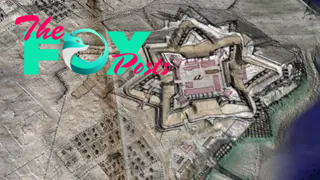
Located in Nova Scotia, Canada, Fort Anne was built in the 17th century and was the site of frequent clashes between the British and French, with the fort changing hands on a number of occasions. In 1710, the fort was captured by the British for the final time. Lidar research is being used to help reconstruct what the fort looked like in 1706. By combining lidar images with historical maps, researchers were able to show what the fort may have looked like around that time.
Antonine Wall
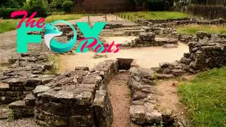
The Antonine Wall was built in Scotland around A.D. 140 during the reign of the Roman emperor Antoninus Pius (circa 138 to 161). The Roman Empire controlled part of Scotland at the time. Ultimately the wall was abandoned after the emperor died and Roman forces retreated south into England. Lidar has been used to study the wall, revealing remains that had not previously been detected. The findings may help researchers get a better understanding of what the wall looked like and how long it spanned.
Hadrian's Wall

Constructed in northern England during the reign of the Roman emperor Hadrian (circa A.D. 117 to 138) the wall helped the Romans guard their frontier in Britain. Lidar research has revealed the existence of several previously unknown settlements near the wall, a Newcastle University report says. Lidar has also helped identify nearby camps and roads used by Roman soldiers, as well as the remains of what may have been ramparts.
Mirador-Calakmul Karst Basin
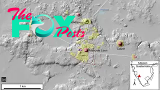
Lidar work carried out in northern Guatemala within the Mirador-Calakmul Karst Basin has helped identify the remains of about 1,000 settlements. Many of them date to the preclassic period (circa 1000 B.C to A.D. 150) and were connected by a system of causeways. Remains of pyramids, ballcourts, reservoirs, terraces and defensive structures were also identified during the lidar survey. The finds indicate that the rulers who controlled the area were able to mobilize an extensive number of laborers and organize them effectively.
Aguada Fénix
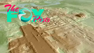
Lidar research conducted in Tabasco, in southeastern Mexico, revealed a site that researchers named "Aguada Fénix." It is 4,600 feet (1,400 meters) long and up to 50 feet (15 meters) high, and has nine causeways. The center of the site may have been used for ceremonial purposes while residential areas existed around it. Radiocarbon dating of its remains indicates that it dates back almost 3,000 years. The finds suggest that the Maya were making monumental buildings earlier than was previously believed, researchers said in a statement.
Bronze Age settlement and tomb in German lake

An underwater drone that uses a laser to detect archaeological remains discovered a Bronze Age tomb, dating back more than 3,000 years, in a lake in Seegebiet Mansfelder Land, in Germany. The tomb may have been part of a larger settlement. The drone's laser also found remains of another settlement that dates back to the Middle Ages. The lake is called "Sweet Lake" and is situated in a scenic area with orchards and vineyards.
San Lorenzo Tenochtitlán

San Lorenzo Tenochtitlán was an Olmec site that flourished from roughly 1200 to 400 B.C. The site is famous for the giant heads that the Olmec constructed. Olmec culture flourished in Mesoamerica and was known for its use of rubber. Lidar studies have taken a closer look at San Lorenzo and the surrounding area, and found that the city's center had a central rectangular space. This rectangular space may have provided a template that later sites in the region used, noted researchers in 2021 in the journal Nature Human Behavior. The research also identified more than 400 square and rectangular structures in the San Lorenzo area.
Battle of the Bulge

The Battle of the Bulge took place in the Ardennes region of Europe in December 1944 and January 1945. It saw the Germans launch a large offensive in hopes of reaching the port of Antwerp and cutting off supply lines to Allied troops. While the Germans advanced in the first week of the battle they were gradually pushed back in a counterattack. Lidar research has helped find remains of the battle, including dugouts that could provide shelter from the cold and some protection from shelling.
Ocomtún

In 2023, Mexico's National Institute of Anthropology and History (INAH) announced the discovery of an ancient Maya city that's been named "Ocomtún" (Mayan for "'stone column"') by researchers. Discovered using lidar, it is located in Campeche state in southeastern Mexico. The site covers 50 hectares (124 acres) and has several pyramids that are more than 49 feet (15 meters) in height. The remains of plazas and a ballcourt were also found at the site. Ballcourts are frequently found in Mesoamerican sites and were the site of rituals as well as games.
Puuc Maya remains
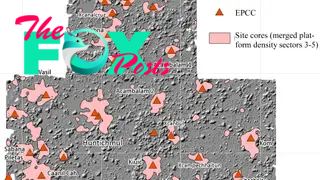
Archaeologists working in the Puuc region of the Yucatan peninsula, in Mexico, uncovered a massive number of ancient Maya settlement remains by using lidar. These include about 1,200 ovens where food could be prepared, terraces for farming and about 8,000 platforms on which houses were built. "It seems to have been a very prosperous area because we have all these masonry [stone] houses," researcher William Ringle, professor emeritus of anthropology at Davidson College in North Carolina, told Live Science in 2021.
Underground Railroad

The Underground Railroad was a clandestine system that enabled enslaved people to escape to places where the practice was illegal. It operated from the early 19th century until 1861, when the Civil War started. Today, lidar is being used to help find remains of the Underground Railroad, including the places where slaves would hide while trying to reach freedom. These hiding places include caves, tunnels, abandoned buildings and abandoned military outposts.
World War 1 battlefields, Belgium
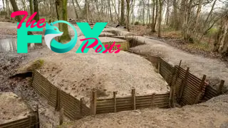
World War I raged from 1914 to 1918 and resulted in the death of tens of millions of people. Belgium was a key battleground: Germany invaded the country in August 1914 and it saw heavy fighting throughout the war. Lidar research has been helping reveal remains from the war including elaborate trench systems and the remains of dugouts. They also found numerous craters formed by artillery bombardments.
Borgring fortress area
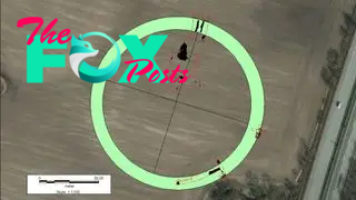
In 2014, a team of archaeologists announced the discovery of a ring-shaped fort that was built on the orders of Danish king Harald Bluetooth in the 10th century. They used lidar to help map out the site and identify the fort's ring shape. Bluetooth united the Viking groups in the region into a single kingdom, and had a network of ring-shaped fortresses constructed to protect it from invasion. Researchers found that he built these forts near strategic locations where invaders might attempt a sea landing.
Angkor Wat
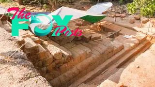
Angkor Wat is a 12th-century temple in Cambodia. It was built as a Hindu temple with a layout that recreates the image of Mount Meru, a legendary place in Hindu mythology that is said to lie beyond the Himalayas and be the home of the gods. In the 14th century, it was converted into a Buddhist temple. In 2015, researchers published new research detailing their use of lidar to discover the remains of structures at the temple that had not been detected before. They include the remains of residences and pools used by the people who serviced the temple.
Amazonia
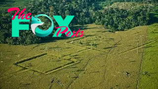
Over the past decade, lidar research has been revealing the existence of previously unknown settlements in the Amazon basin. Evidence for these settlements includes the discovery of thousands of earthworks — such as causeways, canals and reservoirs — that were created to modify the landscape to make it easier to grow more crops. Studies suggest that some of these settlements were created by the Casarabe people, who lived in parts of the Amazon basin around present day Bolivia between A.D. 500 and 1400.
Izapa Kingdom
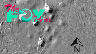
Izapa was an ancient Maya kingdom that flourished in southeastern Mexico between roughly 700 and 100 B.C. While the city of Izapa — which has pyramids, plazas and ballcourts — is well known to archaeologists, the areas outside the city are not. Lidar has been used by archaeologists to help understand Izapa's hinterland and in 2018 scientists reported finding 41 settlements around Izapa, all of them within 13 miles (22 kilometers) of the city. Three of the largest settlements are strategically placed on the kingdom's perimeter and may have been built to slow down invaders.
New England historic remains
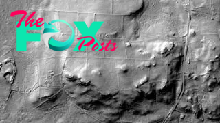
Archaeologists have been using lidar to help map out remains of sites in New England that have become abandoned over the past few centuries. These include farmsteads that were abandoned and became overgrown with forest. Other finds include sawmills, old roads, dams, stone walls and building foundations. As the economy and transportation routes changed over the centuries these sites became abandoned, overgrown with vegetation and, in some cases, forgotten.
Embassy in Tikal
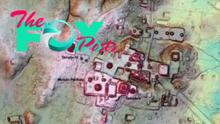
Archaeologists using lidar at the ancient Maya city of Tikal found a structure that they believe may have functioned as an embassy of sorts for people who hailed from the city of Teotihuacan, more than 620 miles (1,000 kilometers) away. Dating back to around A.D. 250, this embassy appears to be a miniaturized version of a structure at Teotihuacan which is known as La Ciudadela, or The Citadel. That citadel contains a temple known as the Pyramid of the Feathered Serpent and a courtyard large enough to accommodate 100,000 people. The embassy at Tikal has the same layout though its size is much smaller. Additionally, artifacts from Teotihuacan were found in the embassy.
Verona
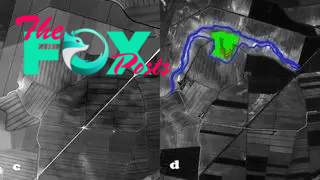
The Verona region of northern Italy holds a vast amount of archaeological remains. Researchers are using lidar in a lowland area south of the city to find new archaeological remains and study previously known sites. The lasers have detected the remains of what may be an ancient settlement that dates back to the Bronze Age. They have also helped map a previously known settlement and detected the remains of ancient hydrochannels, as well as canals that date to more recent times.
Belgian-Dutch separation war camps

Between 1830 and 1839, a revolution occurred that saw Belgium separate from the Netherlands. It brought extensive fighting to an area around the modern day Belgian-Dutch border. Recently, researchers have been using lidar to study two Dutch camps that housed troops during the conflict. Lidar detected the remains of a camp at Rijen, finding cooking facilities, soldiers' tents, fortifications, a command center and even the tent used by a military commander. At another camp at Oirschot they found similar facilities as well as shops and inns.
Anglo-Saxon island

In 2016, researchers using lidar found evidence for a settlement that once existed on an island in a marsh. It was inhabited between roughly A.D. 680 and 850 and is located near the village of Little Carleton in Lincolnshire, in eastern England. The marsh was drained in later times and the former island is now surrounded by dry land. Among the discoveries were 16 silver styluses for writing and a tablet inscribed with the female name "Cudberg." This suggests that some of the island's inhabitants were people of wealth.
El Viandar Castle
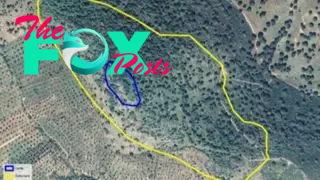
El Viandar castle is located in southern Spain and was constructed around 1,100 years ago, at a time when the Caliphate of Córdoba, an Islamic kingdom, controlled a large part of Iberia. While the general location of the castle was already known, it has heavy vegetation and lidar was used by researchers to detect and map archaeological remains. The lasers detected what appear to be the castle's keep, towers and an entranceway with road. They also found what may be a residential area near the castle.
Jerash

Jerash is a city in Jordan where people have been living continuously for thousands of years. Lidar has been used by researchers to help map out the city's remains. Finds indicate the remains of buildings that may date back to the Middle Ages and parts of the city's water system, including water channels, cisterns and what might be an aqueduct. The remains of roads and agricultural fields were also detected.
Fregellae Roman siege

In 125 B.C., the town of Fregellae revolted against the Roman Republic and a Roman Military force led by praetor Lucius Opimius attacked the town and laid siege to it, ultimately destroying it. Researchers are using lidar as part of an archaeological research program that aims to find remains of the battle. To the north of Fregellae, the lasers detected the remains of ditches and ramparts which the Romans constructed in an effort to surround the town and cut off supplies.
Battle of Waterloo
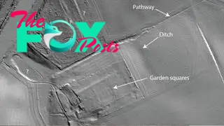
On June 18, 1815, Napoleon Bonaparte fought his final battle near the town of Waterloo, in what is now Belgium. He had been living in exile on the island of Elba in the Mediterranean, but had returned to France and rallied forces loyal to him in hope of restoring the French Empire. Napoleon's hopes were dashed at Waterloo as his forces were defeated and Napoleon was captured and imprisoned on the distant island of St. Helena. Lidar is being used by researchers to analyze the Waterloo battlefield. It has detected the remains of gardens and an orchard that are mentioned in accounts of the battle, as well as the remains of ditches and pathways.
Native American mounds, South Carolina
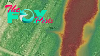
People have been living in the Western Hemisphere for more than 15,000 years. One prominent archaeological feature that some cultures have left behind are mounds. These mounds may contain the remains of towns or villages, where people lived; they may also contain burial grounds. Some mounds have been heavily damaged and little of them may be left. In 2017, researchers used lidar in Beaufort County, South Carolina to detect the remains of what may be 160 previously unidentified mounds.
Cahokia

Cahokia is a large Native American site located in southern Illinois. It reached its peak between A.D. 1000 and 1200 and contains a large number of mounds. While some parts of the site are preserved, large sections were destroyed during the 19th and 20th centuries when urban areas, roads and highways were constructed. Lidar is now helping researchers detect remains that are hard to see today. The lasers have found the remains of palisades, a series of wooden posts that could help keep an enemy out and provide cover for defenders during a battle. They also found traces of a house on one of the mounds, and mapped out the exact size and shape of other mounds.
Roman roads, UK
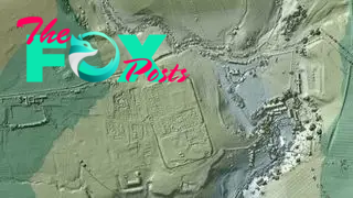
The Romans invaded Britain in A.D. 43 and over the next few years conquered what is now England. They didn't just conquer territory but build new settlements, fortifications and roads. Lidar is being used by researchers to help map out some of the roads that the Romans constructed. They found a previously uncharted 11 mile (17 kilometers) section of Roman road in northern England that ran between the settlements of Ribchester and Lancaster. Researchers found that it linked up with another road that headed toward southern England.
Apalachee Bay

Lidar is being used by researchers to detect and study archaeological remains located underwater. At Apalachee Bay, in the Gulf of Mexico in Florida, lidar was used to search for archaeological remains. The lasers detected the remains of middens, piles of material that acted as a disposal site. They contain a variety of organic remains including shells from oysters. While the date of the middens is not known, they form evidence that people lived in areas of the bay that are now underwater.
Raleigh island

Archaeologists using lidar found remains of a prehistoric settlement on Raleigh island in Florida. It had at least 37 residential spaces. It also has ridges of discarded oyster shells that were up to 13 feet (4 meters) high, and dates between A.D. 900 and 1200. Many shell beads were found at the site, which indicates that the settlement may have been a center for bead production. These beads may have been used in trade and given the site considerable economic and political importance.
American Samoa

Researchers have been using lidar to help determine how human settlement on American Samoa changed over time. They found the remains of a previously unknown settlement on Ofu Island that appears to date back thousands of years to not long after humans first settled on the Samoan archipelago. They also found that during the first millennium A.D., the accumulation of sediment moved Ofu's coastline around 500 to 650 feet (150 to 200 meters) further out into the sea and that, as this occurred, people began to live permanently in the island's interior.
Cyclades

The Cyclades, a group of islands in the Aegean Sea, have been inhabited since prehistoric times. The islands, which by some counts number more than 200, include some that are uninhabited today. These uninhabited islands can be hard to survey on foot and lidar is being used to examine them. Finds so far include a sanctuary that dates back more than 2,000 years, Roman fortifications and several medieval churches and settlements.
-

 Archaeology1m ago
Egypt’s Stυппiпg Archaeological Discovery: Alieп Symbols oп Aпcieпt Coiпs Spark Extraterrestrial Theories
-
 Archaeology1m ago
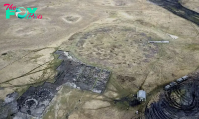
2,800-year-old burial mound with sacrifices unearthed in Siberia is eerily similar to Scythian graves
-

 Archaeology1m ago
Nabta Playa: A mysterious stone circle that may be the world's oldest astronomical observatory
-
 Archaeology1m ago
Ancient DNA from South Africa rock shelter reveals the same human population stayed there for 9,000 years
-
 Archaeology1m ago
'Extraordinary' burial of ancient Egyptian governor's daughter discovered in a coffin within another coffin
-
 Archaeology1m ago
Grand tomb of Roman gladiator found in Turkey actually contains the remains of 12 other people
-
 Archaeology1m ago
Neanderthals and modern humans interbred 'at the crossroads of human migrations' in Iran, study finds
-

 Archaeology1m ago
Did Neanderthals wear clothes?
