Science
Earth from space: Ghostly figure emerges in Greenland ice after underground lake collapses
Where is it? Flade Isblink ice cap, northeast Greenland [81.298483222, -16.071359543]
What's in the photo? A ghostly-looking indentation in the snow
Which satellite took the photo? Landsat 8
When was it taken? June 21, 2014
Scientists were shocked when they discovered a large, ghostly figure that suddenly appeared in satellite images of Greenland 13 years ago. The icy apparition was created by a depression in the snow-covered surface, which formed when an underground lake located directly beneath the figure collapsed.
The blobby specter, which looked like a shapeless figure waving up at space, was spotted in the Flade Isblink ice cap — a roughly 3,300-square-mile (8,550 square kilometers) ice cap sitting on Greenland's northernmost coastline, deep within the Arctic Circle. The icy hole was around 2 miles (3 kilometers) long and just over 1 mile (2 km) across its widest point, and was 230 feet (70 meters) deep when it first appeared, according to NASA's Earth Observatory.
The spooky structure, which researchers also referred to as "the mitten" due to its glove-like shape, formed at some point between Aug. 16 and Sept. 6, 2011, when the area was obscured by cloud cover in satellite photos.
In a 2015 paper, researchers revealed that the depression appeared when a subglacial lake rapidly drained of water, leaving behind an underground cavern that swiftly collapsed. At the peak of this draining event, scientists estimated that 7,600 cubic feet (215 cubic meters) of water escaped the lake every second.
This event was "perhaps the first recorded instance of a rapid drainage of a subglacial lake in Greenland," Kelly Brunt, a glaciologist at NASA's Cryospheric Sciences Laboratory who was not involved in the study, told NASA's Earth Observatory in 2015. The majority of similar submerged lakes in the country are considered to be very stable, she added.
Related: See all the best images of Earth from space

Researchers continued to monitor the depression, and in 2022, a follow-up study revealed that the subglacial lake had been slowly refilling since 2012. By 2021, the floor of the depression had risen by 180 feet (55 m) — rising to 50 feet (15 m) below the surrounding ice — despite a second, smaller draining event in 2019.


NFL prop bets Week 12 2024: Texans vs. Titans

NFL prop bets Week 12 2024: Buccaneers vs. Giants

Chicago Bulls vs. Atlanta Hawks odds, tips and betting trends | November 22, 2024


Nevada vs Vanderbilt Prediction 11-21-24 College Basketball Picks

Texas vs Syracuse Prediction 11-21-24 College Basketball Picks

Carolina Hurricanes at Philadelphia Flyers odds, picks and predictions


-

 Science1d ago
Inside Capitol Hill’s Latest UFO Hearings
-
 Science1d ago
You Won’t Want to Miss the Leonid Meteor Shower. Here’s How and When You Can See It
-

 Science2d ago
Here’s What Trump’s Win Means for NASA
-

 Science5d ago
Why Risky Wildfire Zones Have Been Increasing Around the World
-

 Science6d ago
It’s Time to Redefine What a Megafire Is in the Climate Change Era
-
 Science1w ago
4 Astronauts Return to Earth After Being Delayed by Boeing’s Capsule Trouble and Hurricane Milton
-
 Science1w ago
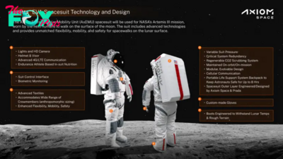
The Elegance and Awkwardness of NASA’s New Moon Suit, Designed by Axiom and Prada
-

 Science1w ago
SpaceX Launches Its Mega Starship Rocket. This Time, Mechanical Arms Catch It at Landing